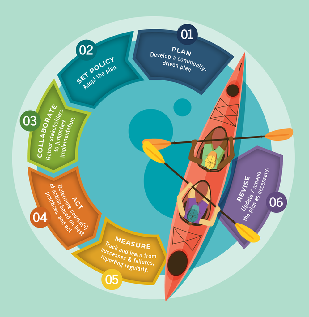
The Columbia Compass is the comprehensive plan – or “blueprint” – for how Columbia, South Carolina will grow and develop over the next ten years.
The City of Columbia conducted research and public engagement on the community's population, natural resources, land use, transportation, housing, community facilities, cultural resources and economy. The plan, adopted in 2020, acts as a guiding policy document for the City, and the recommendations of the plan will be developed for implementation during the coming ten-year period.
What are we asking you to do?
Stay engaged as we move towards implementation! Throughout the planning process you came to our meetings, responded to our surveys, and provided your thoughts. Your involvement will remain critical to our shared success as we move into the implementation phase. Please sign up for our newsletter by entering your email below to get alerts about all things Columbia Compass!
THE PROCESS
POPULATIONA study of historic trends and population projections helps us better understand our community and plan for the provision of services for all. HOUSINGA study of historic trends and population projections helps us better understand our community and plan for the provision of services for all. COMMUNITY FACILITIESWe all rely on community facilities, from utilities and emergency services to parks and educational facilities – how we plan for these services over the next 10 years is vital to the heartbeat of Columbia. |
NATURAL RESOURCESIn identifying our natural resources, we can better understand how to conserve, protect, or improve upon them in the years to come. TRANSPORTATIONTransportation is about mobility and accessibility for all – not just cars, but pedestrians, bikes, transit, freight, and passenger rail. CULTURAL RESOURCESColumbia is a city steeped in culture, from historic structures and fine arts to engaged artists and arts educators. The Amplify Columbia planning process will help define this element. |
ECONOMIC DEVELOPMENTow do we encourage a diverse, resilient, and vibrant economy which attracts employers and employees?
LAND USEHow we look at density, scale, and context – what types of uses are appropriate, and where? PRIORITY INVESTMENTPriority investment acts as a quick reference guide where the recommendations made throughout the plan are compiled and summarized. |
|
|
ENVISION COLUMBIAWhat role does it play?Envision Columbia is City Council's vision and strategic plan for Columbia as it approaches its 250th anniversary in 2036. City Council's strategic plan is updated every two years, and dovetails with the Columbia Compass planning process and recommendations.
|
Stay Engaged!
Meetings and events occurred throughout the planning process, and opportunities for engagement will continue with implementation. Planning Division staff is also happy to come speak to your neighborhood or organization about the planning process or recommendations of the plan. If you're interested in having staff speak to your neighborhood or organization about Columbia Compass, please send us an email.
FIND OUT MORE
FIND OUT MORE
|
Sign up for our newsletter to receive the latest updates about the plan.
|
Columbia Compass is the update to the City of Columbia, South Carolina’s Comprehensive Plan. To learn more about the City’s other planning efforts, please visit the City's website.
Copyright 2024 Columbia Compass. All rights reserved. |