THE PLAN
|
|
Guiding Principles
We believe in...
- Improving transportation safety for all users.
- Providing equitable access to opportunities.
- Supporting great street design that respects neighborhood identities and promotes community investment.
- Improving network resiliency through increased connectivity, green infrastructure, and enhanced multimodal connections.
- Exploring innovative ways to meet the City's current and future needs, including transportation technology, shared mobility, and alternative funding mechanisms.
- Creating a connected multimodal network that improves travel choice and increases the share of Columbians who chose to bike, walk, or use transit for their daily travel.
TRANSPORTATION DOCUMENTS
The transportation element is one of the nine elements of Columbia Compass: Envision 2036.
The transportation element is one of the nine elements of Columbia Compass: Envision 2036.
|
|
TRANSPORTATION CHAPTER (PDF)
The transportation chapter includes a discussion of the above guiding principles; a brief synopsis of existing conditions; official maps; a number of recommendations for the next ten years, as well as supporting case studies; and priority projects. |
|
|
APPENDIX E: TRANSPORTATION (PDF)
A detailed existing conditions report and policy analysis was developed during the research phase of the plan, and a synopsis of the existing conditions report is also included within the transportation chapter. |
|
|
APPENDIX M: WALK BIKE COLUMBIA (PDF)
The Walk Bike Columbia Pedestrian & Bicycle Master Plan, adopted in 2015, is the result of a comprehensive public planning effort, and was initially adopted as an addendum to the transportation section of The Columbia Plan: 2018. As Walk Bike Columbia envisions closer to a 20- to 30-year build-out of infrastructure, the entirety of the plan is carried forward as an appendix to Columbia Compass. |
OUR TRANSPORTATION NETWORK
An analysis of existing data is critical to understanding our transportation network. The slides below provide a brief snapshot; for more detailed information, please see the plan documents listed above.
An analysis of existing data is critical to understanding our transportation network. The slides below provide a brief snapshot; for more detailed information, please see the plan documents listed above.
|
Primary Cause for Vehicular Crashes within the City of Columbia (2017)
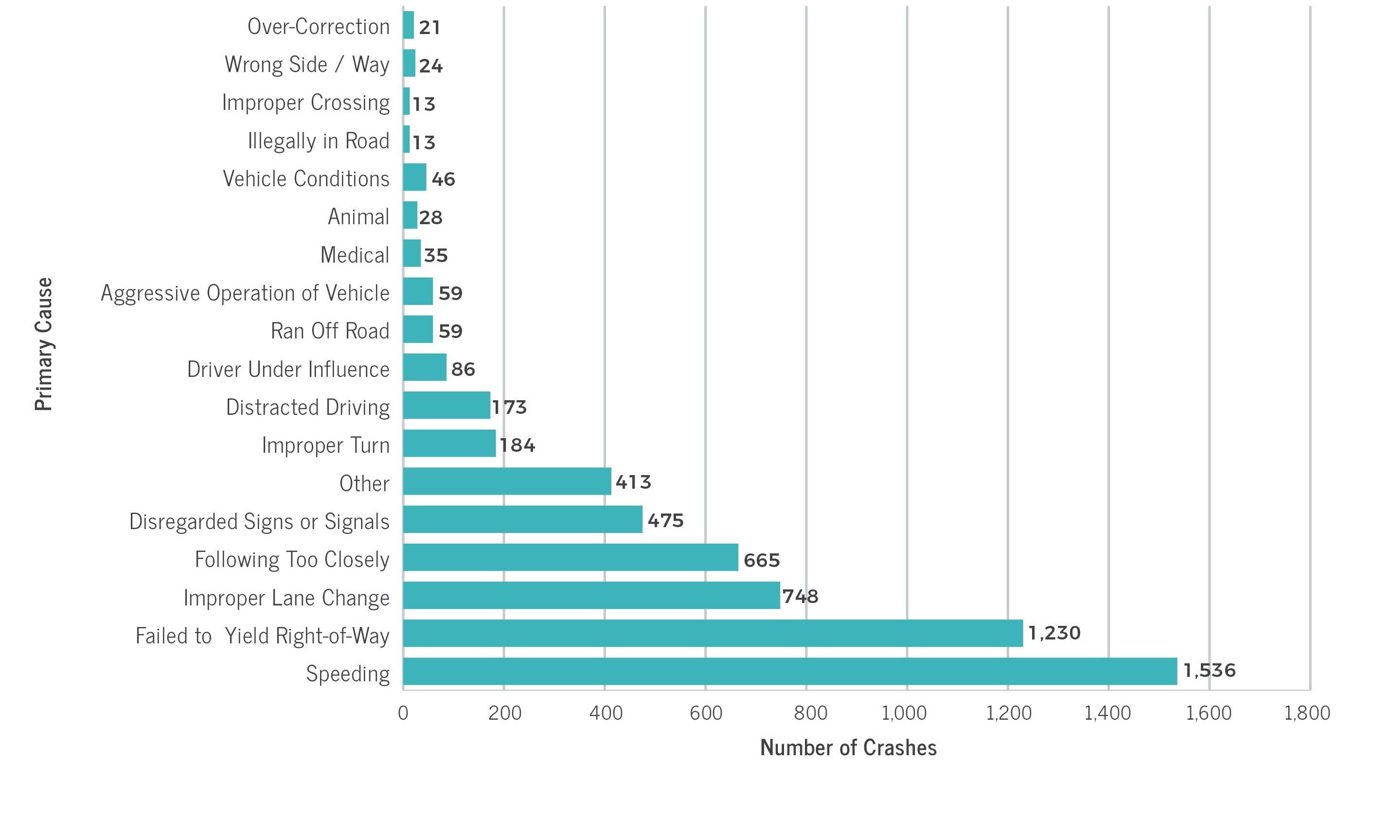
In 2017 the primary cause for the majority of vehicle crashes in the City of Columbia (Richland & Lexington Counties) was due to speeding (1,536). The next leading cause for crashes
was failing to yield the right of way (1,230), followed by improper lane change (748), following too closely (665), and disregarding signs or signals (475). Source: SC Department of Public Safety (SCDPS) data
|
ROADWAY SAFETY
According to the South Carolina Department of Public Safety (SCDPS), there is a collision in South Carolina every 3.7 minutes, an injury collision every 13.3 minutes, and a collision resulting in fatality every 9.5 hours. As of 2017, South Carolina was the highest in the nation, with an overall traffic fatality rate of 180 per 100 million vehicle miles traveled. The chart depicts the primary cause of vehicular crashes in 2017 within the City of Columbia, as assigned law enforcement and collected by SCDPS. |
Walk Bike Columbia
The Walk Bike Columbia Pedestrian & Bicycle Master Plan, adopted in 2015, is the result of a comprehensive public planning effort. The Plan contains an extensive analysis of existing conditions at the time of planning, and examines priorities for programs, policies, and a long-term buildout of pedestrian and bicycle infrastructure, as well as a bike share feasibility study. It is the intent of Columbia Compass: Envision 2036 that Walk Bike Columbia be carried forward in its entirety as a longer-term plan, and as such, it has been incorporated as Appendix M.
CHECK OUT THE PLAN
CHECK OUT THE PLAN
|
IN 2016, ABOUT 21% OF COMMUTERS WALKED TO WORK.

That's over 14,000 people each day, and represents an increase of 10 percentage points over 2010.
|
IT TAKES THE AVERAGE COLUMBIA WORKER ONLY 15 MINUTES TO TRAVEL TO WORK.

That's eleven minutes shorter than the national average of 26 minutes.
|
ROUGHLY 11% OF HOUSEHOLDS IN THE CITY DO NOT HAVE ACCESS TO A CAR

That's much higher than the state average of 6%.
|