Guiding Principles
We believe in...
- Fostering a culture that appreciates and is committed to protecting our natural resources.
- Leading by example - the actions of our employees and our citizens set the standard in our state.
- A Columbia that reduces, reuses, and recycles - decreasing our production of waste and pollutants.
- Clean and accessible waterways.
- A robust urban tree canopy that contributes to the health and beauty of our city.
- A Columbia where our natural resources benefit our community's health.
- A prepared and resilient community in the face of our changing climate.
- A Columbia powered by clean and sustainable energy.
- A data-driven and innovative approach towards natural resource conservation and preservation.
NATURAL RESOURCES ELEMENT DOCUMENTS
The natural resources element is one of the nine elements of Columbia Compass: Envision 2036.
The natural resources element is one of the nine elements of Columbia Compass: Envision 2036.
|
NATURAL RESOURCES CHAPTER (PDF)
The natural resources chapter includes a discussion of the above guiding principles; a brief synopsis of existing conditions; and a number of recommendations for the next ten years, as well as supporting case studies. |
|
APPENDIX B: NATURAL RESOURCES EXISTING CONDITIONS REPORT (PDF)
A detailed existing conditions report was developed during the research phase of the plan, and a synopsis of this report is also included within the natural resources chapter. |
|
WHAT ARE NATURAL RESOURCES, AND WHY DO THEY MATTER?
Natural resources are all around us, even in the urban core. The air we breathe, the water we drink, the food we eat, and the places we play outside are all resource-driven. Natural resources provide clean air, water, food, habitat, opportunities for recreation and tourism, and help mitigate extreme weather events. |
A recent Clemson study found that natural resource-based sectors contribute $33.4 billion in economic activity to the state's economy and are responsible for 218,719 jobs.Greenville Business Magazine January 24, 2018 |
MAPPING OUR RESOURCES
By mapping our natural resources, we can better understand not only the location of critical resources, but also how the fate of these resources, and of our communities, are interconnected. The below slideshow provides an assortment of maps, which are also found in the Natural Resources chapter and appendix. To view a map full screen, click on the image, and the map will open in a new window.
By mapping our natural resources, we can better understand not only the location of critical resources, but also how the fate of these resources, and of our communities, are interconnected. The below slideshow provides an assortment of maps, which are also found in the Natural Resources chapter and appendix. To view a map full screen, click on the image, and the map will open in a new window.
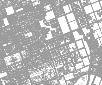
 Illustrative map of commercial impervious surfaces and road rights-of-way in downtown Columbia.
URBAN HEAT ISLANDS: THE NEW SOUTHERN HOT SPOTS
Urban areas tend to be hotter than than nearby rural areas because they contain more impervious areas than vegetative natural areas. These urban areas become "heat islands" because they are warmer than their surroundings. According to the USEPA, heat islands affect communities by increasing summertime peak energy demand, air conditioning costs, air pollution and greenhouse gas emissions, heat-related illness and mortality, and water quality.
Impervious surfaces are areas which rainwater cannot penetrate - surfaces made of concrete or asphalt, roofs, and highly compacted urban soils cannot support vegetative growth or help filter rainwater. This map shows (in gray) commercial impervious areas and roadways in a section of Columbia's urban core.
RESOURCES, ECOLOGICAL FUNCTIONS, & HUMAN VALUE
Our climate is changing, and shifts in the number of hot and cold days, warm nights, and heavy precipitation are also indicators on the changing strain on our natural resources.
Our climate is changing, and shifts in the number of hot and cold days, warm nights, and heavy precipitation are also indicators on the changing strain on our natural resources.

